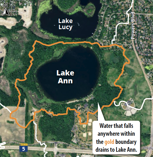
Lake Ann
Located in Chanhassen, Lake Ann is at the headwaters of Riley Creek. Over the past 40 years, Lake Ann has consistently met clean water standards set by the Minnesota Pollution Control Agency (MPCA).
Lake size: 119 acres
Watershed size: 257 acres
Average depth: 16.8 feet
Maximum depth: 40 feet
DNR Lake Ann/ Lake Lucy depth map
DNR Shoreland classification: Recreational Development
MPCA classification: Deep lake (average depth greater than 15 feet)
MPCA Impaired Waters status: Impaired for mercury in fish tissue
Invasive species: Eurasian Watermilfoil, Curlyleaf Pondweed, Brittle Naiad, Common Carp, Zebra Mussel, Purple Loosestrife
Water Quality
Lake Ann is classified as a “Deep Lake” by the MPCA. To be considered healthy, the lake must have very low average phosphorus and chlorophyll-a levels and an average water clarity of 1.4 meters (4.6 feet) or greater.
From June through September every year, District staff visit this and other lakes every two weeks to collect water samples and take readings. Samples are sent to a laboratory to be tested for nutrients and other compounds. Staff also measure water clarity by lowering a Secchi disk into the water and measuring how deep it goes before it is no longer visible. The data indicates the lake’s health based on standards set by the MPCA.
Review an overview of water quality on the Lake Ann factsheetLake Grade
RPBCWD staff assign a letter grade to a lake based upon how well it is meeting water quality goals. This letter grade may be different from that assigned by the MPCA. Learn more about lake water quality grades.
For more information about the water quality and grades for all lakes monitored in the District, visit the lake factsheets page.